
Intro:
Having successfully completed the Gatterl route up the Zugspitze last summer,
and finding myself again in Ehrwald this year, I thought it was time to try
something more strenuous. I sortof fell into the Wiener-Neustädter-hütte
route, as I'd intended to do a slightly easier-sounding one from
Garmisch-Partenkirchen via the Reintal or Hollertal routes. However, I left the
details at home. I'd already been advised last year by a man working in a shoe
shop not to attempt the "front" ascent, but then I never did
take others' advice. I took the route in August 2010 and it was fabulous - a
really exhilarating via ferrata (lit. iron way) hike/climb up the front face of
this fabulous mountain. However, beware - this is a very
hard walk with some very steep drops. Sensible people would take proper ropes
and equipment (I did not) and this is definitely not for those scared of
heights. As with all walks on this site, I take no responsibility for anything
that happens to people who attempt any of my walks - you've been warned!
As usual, I give my actual route with timings:
0809 Leave the Spar in the centre of the village, heading for Gasthaus Panorama in Unterdorf.
0813 Turn right just after Bäkerei Willhelm, turn right, signed "Gasthaus Panorama".
Turn left at the T-junction, following a green sign for "Gasthaus Panorama:
800m". Do not follow
the road, but turn immediately right, following the sign for "Zugspitzehof". There is a meadow
in front of me. After a little while, I reach a yellow signpost, none of which point to
either Gasthaus Panorama or anywhere else on my route.
0828 Reach Gasthaus Panorama and the Wetterstein ski lift. Continue up the wide gravel
path, following the sign for "Gamsalm c.30 mins". Note it opens at 10am and is closed
Tuesdays, as I discovered as I tried to go there for breakfast! Walking up through fairly
sparse coniferous woodland, the road forks and a sign at knee level tells me that the
Gamsalm is on the left fork.
0849 Signpost showing various destinations. The Gamsalmhütte is in front of me, and the sign
points straight on for Wiener-Neustädte-hütte (red route) and Zugspitze (black
route) in front of me.
0853 The hut is closed, and also they don't keep their stamp for my Hüttenpass
outside. Zut!
0857 Lucky I'd had a semmel before leaving the flat, as breakfast turns out to be half a
bottle of Ehrwald spring water from my bag! I carry on up the hill from the hut, up what
appears to be a ski slope.
0917 The ski slope curves left then comes back in on itself and I find myself at the top
of the ski lift of which I was at the bottom at the hut. Ahead is a sheer-looking face of
the Zugspitze, and I can see people on a slightly twisting path halfway up. I
look back to
enjoy the fabulous view across the valley. Go under the top of the ski lift and up a little
path through the vegetation to the right.
0928 Looking up I can see a cable car pylon, and what I assume (incorrectly) is the
Wienerneustätte-hütte.
0933 The path opens out nicely and I find myself walking on scree, presumably
caused
by an old glacier. It's a bowl shape, like the other side of the mountain near the Knörrhütte but smaller.
Ahead I can see the building and the pilon.
0935 Just nearing the end of the vegetation, there's a sign on my right at knee level
telling me that the Wiener-Neustädte-hütte is straight on, Ehrwald is behind me, and that
back and on my left, is the Zugspitzbahn Talstation.
0938 The path zigzags up the scree, marked by slightly lighter gravel and red paint on
the rocks.
0944 I have crossed the scree and reached some more vegetation on the other side.
0947 Look out for the little wooden trough in the stream to your left, carved in 1994.
1001 Back onto the scree, but a little further up. There are some planks, like railway
sleepers, nailed into the path in certain places to create steps.
1009 I am now level with what I thought was the Wiener-Neustädte-hütte, but isn't. It's
accessible by a footpath, but my route carries on up the mountain, not towards the building.
1021 Looking back down on the building which I'd confused with the Wiener-Neustädte-hütte,
it seems to be an old concrete base from the former route of the cable car
(pre-1990s). I
walk up onto a little escarpment and there's a lovely view down to the Zugspitzbahn
Talstation.
1028 A sign directs me the right way.
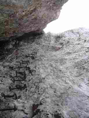
1038 I have just gone under the cable car (some of the lazy people waved to me) and
there's a via ferrata and a cable up the path. There are also some very flimsy-looking
bridges/planks over which the path goes, which don't look all that safe.
1050 I'll be very surprised if the building round the corner isn't the
Wiener-Neustädte-hütte.
1118 Fortunately, it was! The hut was lovely, run by two men who do a mean Kasknödelsuppe
- don't know how they get deliveries up here though! I signed the huge visitor's book which goes back to the 1960s - look for me - Neil Shorney on 10th August 2010 - and had a look round the little
museum in the eating area, with old photographs, an antique fire extinguisher and some other
bits and pieces which were quite interesting. Obviously there's not much to do in the
evening, and there was no TV, so the entertainment corner had a nice selection of board
games and a guitar - very old-fashioned, but nice. A number of people had stayed overnight.
On a poster inside the door there's a photo of the view up to the summit with the route
marked in red, which might be worth taking a photo of if you have a digital
camera with you.
Alternatively, they had postcards for sale also showing the route. I leave the hut and headed up the snow/scree slope towards the summit.
1129 I reach the end of the scree and reach the rock and the start of the
next via ferrata.
It's now that the walk starts to get really serious.
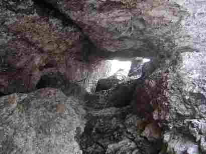
1132 The path now goes into a natural (apparently) tunnel in the rock. It's about 30
yards long and a nice interesting addition to the climb. The cable goes all the way up it.
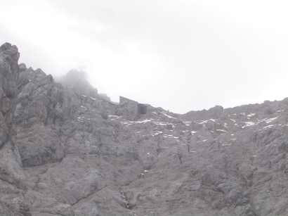
1144 I am partway up the rock face, and the path is quite indistinct in places. It really
pays to have studied the route in the hut before this final ascent. As I go up, I see the
old cable car terminus. It's had quite an interesting evolution since first
opened in the 1920s. It used to
go to the lowest terminus you can see, which then required quite a precarious walk to the
summit. In the 1950s it was extended to just below the summit (on the Austrian side, of
course!), into the existing summit building. Looking up, I can see the old entrance to this
building, in line with the old concrete base further down (no longer visible by this point
in the walk), then the 1920s terminus, then the now glassed-over entrance to the top
building. In 1993 a new cable car was built, which enters the building from a different
angle, which I can see coming up from my right. I can't remember where it used
to go from, but I
think it was closer to the village centre than the current Talstation. The glassed-over
1950s entrance now houses a museum which tells you all about it from the first ascent in the
19th century to the present day, and really is quite interesting.
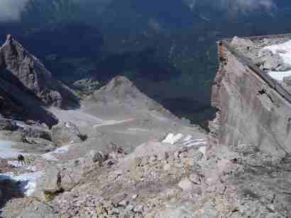
Update: with the station 45 degrees up to my right, the markers end and I head fairly
straight up, following people I can see in the distance in front. It's best to head for just
to the right of the old station, and then the markers reappear.
1238 I am just above the old terminus and decide not to go onto it as the roof is under
snow and might be fragile. This last bit is really hard, as it's as steep as the early via
ferrata bit, except the via ferrata has now ended and you're left with just
rocks. It's steep, difficult to navigate, crumbly and dangerous.
1242 I join the path up from the Knorrhütte route, with a signing pointing to it on the
right and to the Münchnerhaus to the left. That is my destination.
1245 Look out for the old red Austrian border sign on the ridge.
1302 Reached the tourist platform, crammed with tourists, then had about a
20-minute queue for the summit. I celebrated with a schnaps and a Germknödel,
which was possibly the nicest I've ever tasted.
To summarise, this was a fabulous, exhilarating and dangerous hike, walk, climb
up a fabulous mountain!
I'd really love your comments or questions, if you've done the walk yourself, done another of the paths, or are thinking of going. Please use the contact page and get in touch!